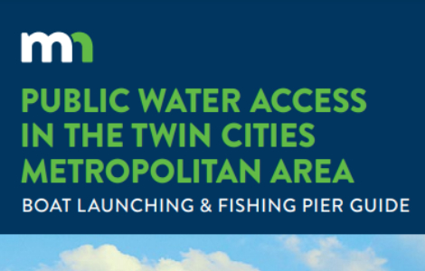
Lake Minnetonka has a long history and is home to thriving businesses and communities dedicated to welcoming visitors and helping them enjoy the lake safely, responsibly and to the fullest. If you’re looking to find public parking, restrooms, a beach, or a map you’ve come to the right place.
The following contains information about available amenities while recreating on Lake Minnetonka. Please note that these amenities are subject to change and some services may have limited hours, charge a fee, or are for customer use only. A PDF version is HERE.
AMENITY CATEGORIES
Summer Accesses
Carsons Bay
Bay: Carsons
Public Access Launch
Public Parking
Public Toilets
Eastman Lane
Bay: Wayzata
Public Access Launch
Public Parking
Public Toilets
Grays Bay Public Access & Marina
Bay: Grays
Public Access Launch
Public Parking
Public Toilets
Head Pump Out
Fuel
Halstead Drive
Bay: Halstead
Public Access Launch
Public Parking
Headwaters Canoe
Bay: Minnehaha Creek only
Public Access Launch
Public Parking
Public Toilets
Hendrickson
Bay: North Arm
Public Access Launch
Public Parking
Public Toilets
Lake Minnetonka Regional Park
Bay: West Upper Lake
Public Access Launch
Public Parking
Public Toilets
Short Term Docking
Maxwell Bay
Bay: Maxwell
Public Access Launch
Public Parking
Public Toilets
Spring Park
Bay: Spring Park
Public Access Launch
Public Parking
Public Toilets
Surfside Park
Bay: Cooks
Public Access Launch
Public Parking
Public Toilets
Tuxedo Road
Bay: Phelps
Public Access Launch
Public Parking
Wayzata, City of
Bay: Wayzata
Public Access Launch
Public Parking
Public Toilets
Short Term Docking
Public On-Lake Facilities
Al & Alma's (Restaurant)
Bay: Cooks
Public Toilets
Back Channel Brewing (5th Street Ventures)
Bay: Seton
Public Toilets
Short Term Docking
Bean's Greenwood Marina
Bay: St. Albans
Public Toilets
Head Pump Out
Fuel
Short Term Docking
Boatworks Marina
Bay: Wayzata
Public Parking
Public Toilets
Head Pump Out
Fuel
Short Term Docking
Caribbean Marina & Restaurant
Bay: Lower Lake South
Public Toilets
Head Pump Out
Fuel
Short Term Docking
Excelsior, City of
Bay: Excelsior
Public Parking
Public Toilets
Short Term Docking
Howard's Point Marina
Bay: South Upper Lake
Public Access Launch
Public Toilets
Head Pump Out
Fuel
Lafayette Club
Bay: Crystal
Public Toilets
Short Term Docking
Lord Fletcher's (Restaurant)
Bay: West Arm / Coffee Cove
Public Toilets
Short Term Docking
Maynards (Restaurant)
Bay: Excelsior
Public Toilets
Metro Lakes Marina & Rentals
Bay: Harrison
Public Parking
Public Toilets
Fuel
Short Term Docking
Lost Lake Harbor / Dakota Regional Trail (City of Mound)
Bay: Cooks
Public Toilets
Short Term Docking
North Shore Marina
Bay: Maxwell
Head Pump Out
Fuel
Short Term Docking
Rockvam Boat Yards
Bay: West Arm
Public Access Launch
Public Toilets
Head Pump Out
Fuel
Shorewood Marina
Bay: Gideon
Head Pump Out
Tonka Bay Marina
Bay: Lower Lake South
Public Toilets
Head Pump Out
Fuel
Your Boat Club
Bay: Smiths
Head Pump Out
Fuel
Certain regulations are in place to ensure commercial dock facilities are operated in a safe and environmentally responsible manner. The following businesses are licensed to operate on Lake Minnetonka and offer boat slips for rent to the public.
Al & Alma's Supper Club (Site 2)
Bay: Cooks
Back Channel Marina
Bay: Seton
Bayside Marine
Bay: Excelsior
Bean's Greenwood Marina
Bay: St. Albans
Boatworks Marina
Bay: Wayzata
Brown's Bay
Bay: Tanager
Brown's Bay Marina
Bay: Browns
Chapman Place Marina
Bay: Cooks
City of Excelsior
Bay: Excelsior
City of Minnetonka
Bay: Grays
City of Orono (Transient)
Bay: Big Island
City of Wayzata
Bay: Wayzata
Excelsior Marina (500 NNL, LLC)
Bay: Excelsior
Howard's Point Marina
Bay: S. Upper Lake
Lindbo Landing
Bay: Echo
Metro Lakes Marina
Bay: Harrisons
Minnetonka Marina
Bay: Gideon
North Shore Marina (Browns Bay)
Bay: Browns, Tanager
North Shore Marina (Maxwell Bay)
Bay: Maxwell
Rockvam Boatyards
Bay: West Arm
The Caribbean
Bay: Echo
Tonka Bay Marina
Bay: Echo
Tonka Bay Sales (Site 1)
Bay: Excelsior
https://www.tonkabaymarina.com/home
Tonka Bay Sales (Site 2)
Bay: St. Albans
https://www.tonkabaymarina.com/home
Wayzata Marine
Bay: Maxwell
Your Boat Club
Bay: Smiths
The following clubs operate on Lake Minnetonka out of licensed facilities.
America's Boating Club
Bay: Big Island Passage
Lafayette Club
Bay: Crystal
Minnetonka Yacht Club
Bay: Carsons, St. Louis
Upper Lake Minnetonka Yacht Club
Bay: S. Upper Lake
Wayzata Yacht Club
Bay: Wayzata
Certain regulations are in place to ensure charter boats are maintained and operated in a safe manner. The following businesses are licensed for operation on Lake Minnetonka with various amenities such as alcoholic beverage service. The authorized ports of call where passengers may be picked up or droped off also varies. Other than encouraging the public to use licensed businesses for their health and safety, the LMCD cannot make recommendations. Please check with the Better Business Bureau or other rating services for business references.
Al & Alma's Supper Club
Liquor License Type: Full Liquor
Ports of Call:
Al & Alma’s (Mound), Excelsior City Dock, Lafayette Club (Minnetonka Beach), Wayzata City Dock
Lady of the Lake, Inc.
Liquor License Type: Full Liquor
Linda Lee Charters, LLC
Liquor License Type: Full Liquor
Museum of Lake Minnetonka (Not in operation for 2022 season)
Liquor License Type: None
Ports of Call:
500 NNL LLC (Excelsior), Excelsior City Dock, Wayzata City Dock
PaddleTap, LLC
Liquor License Type: Beer (BYOB)
Ports of Call:
5th Street Ventures (Spring Park), Excelsior City Dock, Lord Fletchers (Spring Park), Metro Lakes Marina (Mound), Wayzata City Dock
Paradise Charter Cruises
Liquor License Type: Full Liquor
Tonka Yacht Rental
Liquor License Type:
Ventur Holdings, LLC
Liquor License Type:
Ports of Call:
Wayzata City Dock
Wayzata Bay Charters, Inc.
Liquor License Type: Full Liquor
Ports of Call:
500 NNL LLC (Excelsior), Excelsior City Dock, Wayzata City Dock
Lake Minnetonka’s public swimming beaches are listed below and indicated on the map. Follow this LINK to the Hennepin County website for more information about beach closures and water sampling.
Note: Libbs Lake Beach water sampling is conducted by the City of Minnetonka. For more information, call the City at 952-939-8200.
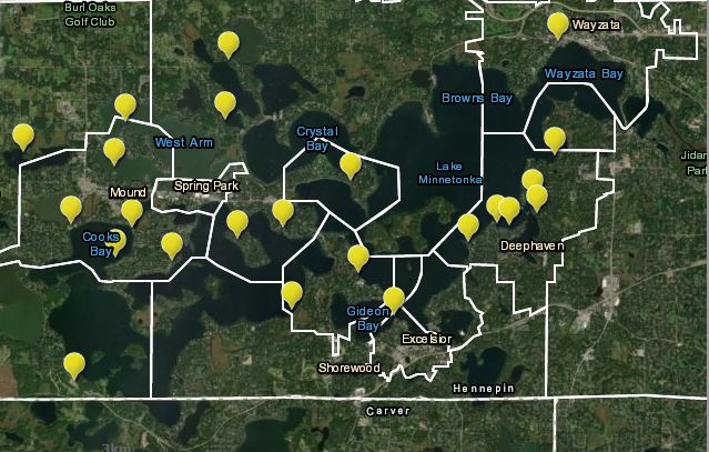
Beach Park, Minnetonka Beach
Canary Beach, Mound
Camp Teko, Orono
Casco Beach, Orono
Centerview Beach, Mound
Chesters Beach, Mound
Crescent Beach, Shorewood
Deephaven Beach, Deephaven
Excelsior Commons Beach, Excelsior
Lake Minnetonka Park Swim Pond, Minnetrista
Libbs Lake Beach, Wayzata
Linwood Beach, Deephaven
Lydiard Beach, Orono
Nocomo Beach, Deephaven
Robinsons Bay Beach, Deephaven
Rocky Beach, Deephaven
Sandy Beach, Orono
Sandy Beach Northern Road, Deephaven
Surfside Park Beach, Mound
Sherven Park Beach, Mound
Wayzata Beach, Wayzata
Wekota Beach, Tonka Bay
Wychwood Beach, Mound
Lake Minnetonka is unique not only for its many bays but also for its many bridges. In fact, there are 20 bridges scattered across Lake Minnetonka’s 14,500 acres. All of them may stand at different lengths, widths, and clearances but all share one thing in common: they connect. Whether you are driving down Shoreline Drive across Arcola Bridge towards Wayzata or driving down Shadywood Road across Narrows Bridge toward Excelsior, these bridges connect us all to our destinations. But best of all, they connect all 14 cities that surround this beautiful lake.
The table below displays the approximate clearance, length, and width measurements of each bridge found on Lake Minnetonka. Note: vertical clearance measurements are based on the normal lake level elevation of 929.4 feet. Channel depths and slops may vary.
| Bridge Name | Clearance | Length (ft) | Width (ft) |
| Arcola | 14’9″ | 596 | 55 |
| Black Lake | 9’9″ | 95 | 46 |
| Boy Scout | 6’11” | 51 | 21 |
| Carson’s Bay | 5’8″ | 388 | 54 |
| Coffee | 13’6″ | 119 | 45 |
| Emerald Lake | 12’4″ | 92 | 44 |
| Forest Bay | 11’3″ | 158 | 44 |
| Grays Bay | 14’4″ | 297 | 45 |
| Halsted Bay | 14’11” | 56 | 43 |
| Hendrickson | 14’11” | 113 | 46 |
| Libbs Lake | 8’10” | 78 | 34 |
| Lost Lake | 11’1″ | 118 | 43 |
| Narrows | 18’3″ | 319 | 59 |
| Noerenberg | 12’8″ | 128 | 50 |
| Peavey | 9’0″ | 65 | 28 |
| St. Albans Bay | 12’5″ | 106 | 35 |
| Seton Lake | 12’8″ | 138 | 66 |
| Tanager Lake | 9’0″ | 93 | 40 |
| Zimmerman Pass | 11’6″ | 152 | 27 |
Know Your Markers Before You Set Sail!
Buoys are considered the “road signs” of the water. Some fixed signs on poles or bridges also provide instructions and reminders for boaters and other lake users about regulations and some known hazards. It is important to remember that buoys are strategically located to balance navigation needs, financial costs, and use of the lake without the markers becoming obstructions. Therefore, lake users are responsible for understanding the regulations, slow/no wake distances, and be aware of potential dangers given the change in seasonal and yearly lake characteristics such as fluctuating water levels. Swimmers and other lake users should also recognize the types of buoys and potential hazards to prevent accidents.
  |
Green & Red BuoysA channel lies between green and red markers. A channel may appear to be defined by land, but it may also be defined by physical characteristics under water such as rocks or shallow water. Keep green buoy markers on your left (port) side when heading upstream. Keep red buoy markers on your right (starboard) side when heading up stream. Some red and green channel buoys are lit by solar lights to help with navigation through certain designated channel areas during nighttime or sudden inclement weather. Please contact LMCD to report specific locations of damaged or nonworking lights. |
 |
Obstruction BuoyA black and white vertically striped marker indicates an underwater obstruction. Do not pass between multiple markers of this type or between this marker and the shoreline. |
 |
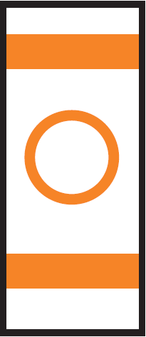
Mooring BuoyA round and horizontally striped mooring buoy is used to secure vessels. This is the only marker that a boat can legally be tied to as part of a multiple dock license from the LMCD or in a lakeshore property owner’s dock use area. Be aware that a vessel may be secured to such a buoy or a buoy may exist alone in the water when a vessel is not moored to it. |
 |
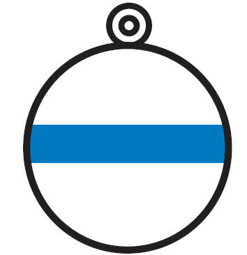
Diving BuoyA diving flag is used to indicate the presence of divers in the area. This means a boater must keep at least 150 feet away from the flag or a greater distance if needed to prevent unreasonable wakes. Navigate with extra caution in this area. |
 |
Controlled Area BuoyA marker with a circle indicates rules in a controlled or regulated area, such as speed limits, slow/no-wake, and wash restrictions. Follow the restrictions displayed within the orange circle. On Lake Minnetonka, controlled areas also exist throughout the lake even if a buoy is not present. A baseline slow/minimum wake areas of at least 150 feet for general watercraft and 300 feet for Personal Watercraft performing repetitive passes. These minimum distances are from shorelines, docks, swim areas, and anchored watercraft. Distances may need to be greater to reduce wakes if the wakes are high enough to be harmful to lakeshore, docks, anchored fisher people or other lake users. Certain areas are designated as Quiet Water Areas all the time or during certain times. Learn about Own Your Wake for Everyone’s Sake. |
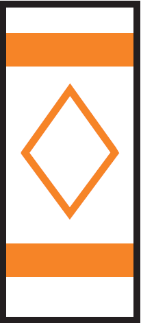 |
Danger BuoyThe diamond shape on this marker indicates the presence of nearby dangers such as shoals and rocks. Information about the hazard is displayed within the orange diamond. |
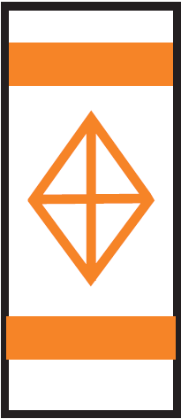 |
Keep Out BuoyA diamond shape with a cross indicates exclusion or closed areas where boats are prohibited. Steer clear! |
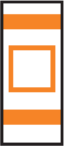 |
Information BuoyA marker with a square provides helpful information such as directions, distances, and locations in the area. Use the information inside the square as a guide. |
Requests for Additional Buoys
Requests for additional buoys are made each year throughout the lake. It is important to remember that buoys are strategically located to balance navigation needs, financial costs, and use of the lake without the markers becoming obstructions. Installation of more buoys is not always effective in addressing concerns. Public education has increased to inform the public about proper and safe navigation. With the increase of lake use, LMCD increased funding for water patrol services during the summer to aid in enforcement of regulations and for emergency response.
To request installation of additional public or private buoys, a letter may be submitted to the LMCD Office to request the installation of additional public or private buoys. Sufficient evidence must be submitted to support the installation of additional buoys at the location. Providing video and photo evidence of the potentially dangerous or destructive circumstances is helpful when presenting the request to the LMCD Board of Directors.
Public Buoys
Public buoys may be requested by members of the public. The Board may choose to install public buoys and pay for the costs. The board has opted to install public buoys in the past for Big Island and Quiet Water Areas after significant review of the area over a summer or more.
Private Buoys
In certain cases, the board may approve private buoys—for which the costs, installation, and liability would be a private party’s responsibility. Buoys must meet the required US Coast Guard and MN DNR specifications. Representatives of a party, mostly research projects, must apply for a permit to install private buoys beyond 200 feet from shore (under both temporary structure and special event permits) and other conditions may apply. Historically, staff works with the Hennepin County Sheriff’s Office Water Patrol Unit (HCSO Water Patrol) for the issuance of temporary structure permits.
Requests for Quiet Waters Area (QWA)
In other cases, the board may approve designate a quiet waters area (QWA) in an area where there are expressed concerns for public safety, traffic violations, and environmental impacts. A petition may be submitted to the LMCD to request the the designation of a QWA. LMCD staff will review the request by conducting observations at the site on separate occasions throughout the summer or two to gather video, photo, and written evidence of potentially dangerous circumstances. LMCD staff will present the findings related to public safety, record of traffic violations, concern for environmental impacts, or other concerns to the board for review.
LMCD staff has received requests for QWAs in previous years. Most recently, the LMCD Board approved a request for QWA at Cedar Point West buoy channel between Cooks Bay and West Upper Lake. QWAs are listed in the 2022 Summer Rules Brochure in a map displaying the designated areas.
Solar Lights
Over one hundred solar lights are installed on channel navigation buoys across Lake Minnetonka each boating season. The solar light program is funded by contributions to Save the Lake and volunteers assist in the program. Broken or loose solar lights should be reported to the LMCD office with the specific location identified.
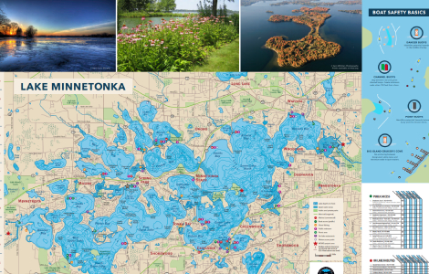
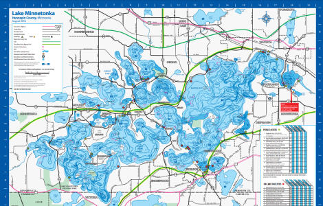
Lake Minnetonka Maps
Lake Minnetonka stretches 10.9 miles and covers 22.7 square miles – it’s a big lake surrounded by 14 municipalities, dozens of local businesses and public spaces, and hundreds of private homes. Explore varying aspects of Lake Minnetonka using the maps below.