

The following information is a summary of the Lake Minnetonka Conservation District (“LMCD”) licensing and permitting process that you may find helpful for your project. However, it is just a guideline and is subject to change. All applications are subject to the procedures, requirements, and limitations of the LMCD Code and are specific to the request and characteristics of the site. Also, be sure to size your watercraft and structures appropriately to accommodate the site characteristics, as well as fluctuations in water levels, vegetation, and other conditions from year to year. For specific license/permit application information and references to additional state and local requirements, visit the links on the Applications & Licenses webpage.
The overall timeline and process is generally prescribed by Minnesota State law. In addition, LMCD coordinates the process with a number of agencies. Therefore, it is especially important to allow sufficient time to plan, process, and prepare for a dock, structure, business, or other project. The application process typically takes 60-120 days, depending on the complexity of the project. Minor changes that are eligible for administrative review generally take 30-60 days. Anticipate up to 15 working days from the initial submission of the application to determine if the application is deemed complete or if more information is needed to start the next phase of the application review process.
Application
The process to request a license or permit starts with the submission of a complete application to the LMCD. Incomplete/invalid applications, or those that are not accompanied by the required application fee and escrow, will not be processed. The link to the application can be found on the LMCD website under “Applications” or specifically at this link. If a variance is being requested for practical difficulties, please visit the variance process webpage.
Every application is site specific and reviewed based on the code to protect the health of the lake, as well as facilitate reasonable, safe, and equitable access to the Lake.
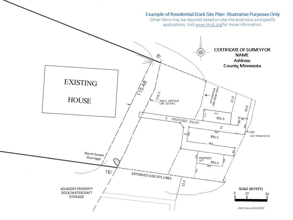
The following items are typically required as part of an application and site plan.
General Site Information
- Site address/PID/Location
- Property owner name
- Contact information
- Applicant (authorized agent relationship to property)
- Contact information
- Submit a digital version and hardcopy 11 inch x 17 inch site plan- drawings and inclusions must be to-scale
- Indicate North direction
- Extensions of property’s side site lines on both/all points on the property where they terminate at the shoreline
- Documented shoreline (929.4 ft OHW) and respective total measurement of lineal footage of shoreline
- Documented lines showing 50 ft, 100 ft, and 200 ft measurements into the lake from the 929.4 ft OHW NVGD
- Any utilities: environmental features such as wetlands, protected vegetation or spawning areas, etc.; unique characteristics of the dock use area; adjacent channels or lagoon areas; and other items relevant to the site. If located adjacent to or near a channel or other main navigation thoroughfare, include the dimensions of the channel or navigational area, including to the opposite shoreline, any navigational hazards, and any docks or structures.
Specific Site Information
- Measurements of existing dock structures, watercraft storage areas, and other structures
- Measurements of proposed dock structures, watercraft storage areas, and other structures
- Location and identifying label for watercraft storage for all boat storage units (BSUs)
- Dimensions of of all BSUs including length and width
- Setback measurements from both/all extended side site/property lines for docks, watercraft storage areas/BSUs, and other structures
- Length measurement from the 929.4 ft OHW of the dock including watercraft storage and other structures
- Abutting docks and other structures at adjacent properties indicating effect of the variance request including distance measurements and other relevant items
- Water level readings (if water depth is the basis of the variance request or required as part of the application) to include first reach to 3 feet, 4 feet, and 5 feet from the 929.4 ft OHW along the continuous shoreline. Include the dates water depth measurements were taken. Water depths must be measured relative to the 929.4 ft OHW NVGD.
Process and Timeline
Once a completed application is submitted, the LMCD will begin processing. Anticipate up to 15 working days from the initial submission of the application to determine if the application is deemed complete or if more information is needed to start the next phase of the application review process. Please keep in mind it may take up to 30 days minimally and up to 120 days to process the application, depending on the type and complexity of the request. Please note that typically only one meeting is scheduled for November and December. This does not include the time to process an EAW and EIS if needed.
Minor Change Applications
Minor change applications include projects that are limited in scope for reconfiguration or size transfer of structures or watercraft. In these cases, the code allows the application to be processed administratively with a public hearing or Board approval. Similar information is required for applications that meet minor change requirements or Board approval. The timeline is typically 30-60 days depending on the project details.
Applications Requiring Public Hearings & Board Approval
For applications that requires a public hearing or Board approval, the timeline is typically 30-60 days depending on the project details, and does not include time to process and EAW or EIS. The process includes a notice of a public hearing, which is published and mailed to owners within 350 feet of the subject property or 500 feet depending on the type of license if included in the application request. The applicant is required to obtain mailing labels from Hennepin County or Carver County for property owners within a 350-foot radius of the site. Labels are now available online by visiting https://gis.hennepin.us/locatenotify/default.aspx. The LMCD also coordinates the process and forwards the application to other public agencies for review and comment.
The Board receives the application along with a staff report, which includes additional information about the site and makes a recommendation about the requested application for the Board to consider. Once the public hearing is conducted, the Board then discusses the application and directs the LMCD attorney to draft Findings of Fact and Order for either approval or denial of the request. The Findings of Fact and Order are typically brought back before the Board at a subsequent meeting for consideration of adoption. A copy of the adopted Findings of Fact and Order are then provided to the applicant. The applicant, and any subsequent purchaser of the property, is required to comply with the license, permit, variance and any conditions placed on it.
Please contact the LMCD if you have questions.