Lake Minnetonka WEATHER

Water Level & Quality

Determining Lake Water Levels

The Ordinary High Water (OHW) level for Lake Minnetonka is 929.4 feet. It is natural for the water levels to fluctuate, seasonally from spring to fall and each year depending on weather conditions. The LMCD staff monitors lake water level readings taken by the USGS and Minnehaha Creek Watershed District (MCWD), which is charged with managing water levels on Lake Minnetonka and downstream to mitigate flooding and balance conditions during drought. Water levels are managed where feasible by controlling the operation of the Grays Bay Dam. This process is also coordinated with Minneapolis Park Board and its water level control mechanisms. View real-time readings of Lake Minnetonka by the USGS HERE. Find water level readings at www.minnehahacreek.org.

When the water levels are too high or too low, extensive damage may occur to the lake and shorelines. It also can lead to safety hazards for people, pets, and wildlife. Therefore certain regulations are in place to minimize these risks, balancing reasonable use of the lake.

Learn more about High Water an Low Water declaration regulations and information by scrolling through the menu above.

High Water Declaration

When lake water levels are high, extensive damage can occur to the lake shoreline, docks, and other structures due to wakes created by boaters and winds. These conditions may also lead to accidents and injuries for people, pets, and wildlife. To minimize damage to the lake, people, and property, a “High Water Declaration” is put into effect. Enhanced education and monitoring of the minimum wake areas will occur. See the General High Water Declaration Handout for a map and summary of the requirements.

NOTICE: In situations where the water levels are high, but not to the extent of an official High Water Declaration, enhanced monitoring of the general slow wake zones will likely occur. For a map and details of typical slow and minimum wakes areas, see the Summer Rules Brochure.

Water Level Thresholds

High Water Declaration and restrictions are typically implemented as follows:

  • Goes into effect when water levels are at or above 930.0 feet for eight consecutive days.
  • Goes into effect when water levels are at or above 930.25 feet.
  • May be declared when water levels are at or above 930.0 ft for five consecutive days under certain circumstances.

High Water Restrictions typically end as follows:

  • When lake water levels fall and remain below 930.0 feet for a period of three consecutive days.

High Water Declaration Restrictions

While Lake Minnetonka remains open to public use and enjoyment, during a High Water Declaration, watercraft operators must adhere to the additional minimum wake restrictions as follows:

  1. Watercraft must be operated at a speed less than five miles per hour or at a speed that creates more than a Minimum Wake in certain bays and areas.
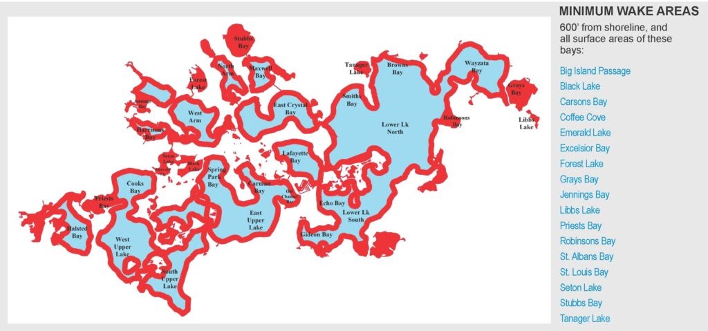
  2. Regulated areas are defined as the surface area of the Lake within a distance of 600 feet of the entire shoreline, as well as all of the surface area of specific bays and portions of the Lake as indicated below.
  3. Minimum Wake means the wake moving out from and trailing behind a watercraft in a widening “V” that is of a size that will not negatively affect other watercraft or be detrimental to the shoreline. It is unlawful for a person to operate a watercraft in regulated areas of Lake Minnetonka at a speed of more than five miles per hour or a speed that results in more than a minimum wake.

High Water Safety Tips

The following are some safety tips that may be helpful until the water level subsides. Items may change depending on the water level and time frame of high water.

  • When wet, some dock materials are slippery, so be careful when walking on wet docks.
  • After an extended period, algae and other plants may grow on wet docking and structures, creating potential slipping hazards.
  • Watch for floating debris or bogs that may be displaced due to high water.
  • Watch for structures and hazards in the lake that may be visible during ordinary high water but are beneath the surface due to higher than normal water levels.
  • Make sure docks and other structures are secured to avoid parts floating away and creating hazards or nuisances.
  • Check electrical and plumbing connections for safety on the docks and on land.
  • Remove any items that may be located on land or shore that could float into and pollute the lake. (Chemicals, batteries, fuel, leaves, brush, floatables, etc.)
  • If possible, delay dock installation until the water stabilizes and possibly lowers, so it is at the appropriate heights if the water level decreases.

Additional Resources

  • Summary When High Water Declared-– Handout
  • If you have questions about the regulations, contact LMCD at 952-745-0789 or lmcd@lmcd.org.
  • To request officer assistance or report a violation, contact Hennepin County Water Patrol at 952-258-5321.

Low Water Declaration

When the Lake Minnetonka water level falls below 928.0 NGVD, the Board may declare low water by resolution. When this occurs, the public will be notified. Some options are in place to extend dock length upon certain conditions. When the water levels reach 928.6 NGVD for 5 consecutive days, the Low Water Declaration is automatically cancelled.

Situation 1. General Permit for Temporary Extensions- Residential Docks

Residential properties may extend their docks without a permit if all the following conditions are met:

  • The dock is a seasonal and temporary type.
  • The length of the dock is 30 ft beyond the dock use area if 928.0 ft NGVD, and 60 ft if 927.0 NGVD.
  • The water depth may not be greater than 5 ft depth at the 928.0 NGVD.
  • The dock must not impair navigation or create a hazard.
  • The property has no past variances.
  • The dock must be readily visible- designed, constructed, elevated, lighted and/or reflectorized.
  • The dock must be secured and constructed so dock sections don’t float away during higher water or wave conditions.
  • The docks are subject to inspection at reasonable times.
  • The property owner must register the dock extension request with the LMCD using the LMCD form. Registration is required for each low water event.

Standards and Removal for temporary dock extensions.

  • Compliance. If the dock is not in compliance, it is grounds for revocation and future permit ineligibility.
  • Modification. Modification may be required upon notice and a public hearing.
  • Removal. Lawful temporary dock extensions are require to be removed by November 15th, even if low water is cancelled. Property owners that do not move their docks inward or keep extending their docks often create additional navigation issues as the sediment settles within their dock use areas.

Situation 2. Temporary Low Water Permit- Commercial & Multiple Docks

Commercial, multiple dock, and mooring facilities may apply for a temporary dock extension permit.

Situation 3. Temporary Low Water Variance- Otherwise Ineligible Sites Option

Properties that are not eligible for temporary dock extensions or low water permits may be eligible for a temporary low water variance for a specified time period. A public hearing is required unless the board waives the requirement. Further, the board may waive formal application requirements. Transferee sites may also be eligible. If approved, the following conditions apply:

  • Submit an Application Permit to the LMCD on the form that includes site plan showing location and proposed length. The site must be in compliance with density and size requirements.
  • Removal or relocation of the dock for the winter season may be required.
  • The property may not be eligible if past variances or other limitations are in place per LMCD Code 10-2.03.
  • Renewal. Permits issued after 03/01/2013 may be eligible for automatic renewal if there are no changes to the approved dock, no violation, or notice of violation.

Water Quality Information

Lake Minnetonka is an unique waterbody because each of the forty-two bays that form this lake vary in surface area, depth, and water quality. The LMCD is committed to enhancing the enjoyment of Lake Minnetonka by preserving its water quality through aquatic invasive species management and pollution prevention.
For more information, the Minnehaha Creek Watershed District (MCWD), Minnesota Pollution Control Agency (MPCA), and University of Minnesota all have great resources that everyone can access to learn more about the water quality of Lake Minnetonka as well as other Minnesota lakes and rivers.

The MCWD Water Quality Dashboard displays the health of lakes and streams throughout the watershed. Three core indicators are collected and analyzed routinely to determine whether the health of a lake or stream is generally healthy or impaired. If your curious to know how your lake, bay or stream is fairing; simply click the link to examine the data.

Every two years, the MPCA assesses all waters in the state and creates a list of impaired waters as required by the Clean Water Act. This list is based on intensive water monitoring of major lakes and streams along with data from outside partners. It is used to set pollutant-reduction goals needed to restore impaired waters. More information can be found using the link.

This map provides satellite derived water clarity data for over 10,000 Minnesota lakes including Lake Minnetonka. Give it a look to find out how clear your lake is.

The Minnesota Pollution Control Agency has lots of great information about lake water quality monitoring, blue-green algae, water pollutants, and water quality initiatives. Visit the link to learn more.

To learn more about ways to preserving Lake Minnetonka Water from Aquatic Invasive Species & Trash, visit the links below.