Some Items to Consider
The Minnesota Legislature established the LMCD (Minn. Stat. §§ 103B.601-103B.645) more than 50 years ago to help protect the lake, public safety, and the environment. The LMCD’s mission is to preserve and enhance the Lake Minnetonka experience so it continues to be an attractive place to live, do business, and recreate. One of the ways the LMCD carries out its duties is through the development and adoption of regulations and initiatives that apply to uses of the lake.
The characteristic and conditions of the shoreline, water depth, environmental areas, legal encumbrances, and other factors may determine how a property may be used for things like docks, watercraft (types, size, number, etc.), etc. The regulations are somewhat similar to those applicable to on-land storage of vehicles, which can be influenced by the characteristics of streets, landscapes, and driveways. Those new to the lake, or are considering purchasing land on the lake, often have questions about the LMCD and how its regulations affect what can be done on the lake. The following provides information regarding some of the most frequently asked questions to serve as a starting point for those wishing to learn more about how the LMCD regulations affects the use of the lake by adjacent property owners.
Since the lake has so many unique characteristics, please contact the LMCD office for information specific to a particular site. Also, please keep in mind the LMCD cannot recommend whether you should purchase a property and cannot guarantee how its regulations may affect use of the lake in the future. The LMCD can provide information on its current regulations, but any use requiring a permit cannot be decided upon until an application has been processed in accordance with the LMCD Code of Ordinances (“Code”). To aid in the review of a property, a general view and measurement of a property is typically available through the aerials provided on the Hennepin County interactive property map or Carver County interactive property map.
Easements
Generally, for purposes of applying the Code, the riparian rights for the entire site are considered. In cases where those riparian rights are shared among multiple parties for a particular site, the overall site must cumulatively comply with Code requirements. An easement grants the holder a legal right to use another’s land for a specific limited purpose, such as lake access. The legal title to the land remains with the owner of the land. There are a variety of types of easements including, but not limited to, private property easements, conservation easements, public easements, or other types.
If the property you are considering has access to the lake through an easement, be sure to review the language of the easement carefully and consult with your attorney. Easements may provide shared riparian rights that affects the Code allowances such as setbacks and watercraft density. Please refer to our Residential Docks, Structures, and Watercraft handout for setbacks, length, watercraft density, and other requirements.
Common Land
Some entities may have riparian rights for lakeshore properties. For instance, the City of Mound has common land that is dedicated for use as part of their multiple dock program. Other cities may have certain riparian rights to use lakeshore as part of their multiple dock program or for parks or beaches. Homeowner associations may have riparian rights to certain lakeshore or the lakeshore may be dedicated as part of a multiple dock license.
Water Depth
It is important to know the existing water depth in relation to the 929.4 Feet ordinary high water (OHW) level for Lake Minnetonka. The water depths vary significantly in bays and even within the same bay. They also vary depending on the time of year and amount of precipitation. For example, water levels in the fall could be 12 inches below OHW level. Also, if a dock is not used over time, the sediment may accumulate in the location. Therefore, it is important to know the depth or draft of the watercraft intended to be stored at the property as compared to the depth of the water in the area.
Special Lake Characteristics
There are many situations that may affect the use of the lakeshore property. A few to mention include unusual or converging lot lines, lagoons, proximity of channels, or heavy traffic areas.
Variances
The LMCD may have issued one or more variances related to a particular property. A variance is a request to deviate from one or more of the requirements of the Code. Section 6-5.01 of the Code outlines the variance process and requirements. A variance is a limited tool available to address unique situations where the strict application of the Code creates practical difficulties based on conditions unique to the property. The property or neighboring properties may have variances that permanently alter the dock use areas or watercraft allowed.
Number & Type of Watercraft Allowed
The number of watercraft that can be stored at a property is based on the measurement of the shoreline at the 929.4 Feet OHW. This restriction applies to “restricted watercraft” and includes personal watercraft, runabouts, cruisers, pontoons, fishing boats, and similar types of watercraft. The following watercraft are considered “unrestricted watercraft” and are not included in watercraft density calculations, if they are not stored on or over the water:
- 16 ft or less in length without a motor
- 16 ft or less with a motor 10 hp or less (manufacturer specs and regardless if operational)
- 20 ft or less without a motor and propelled solely by human power. Ex. Canoe, kayak
Be sure to check with the city the property is located in to determine on-land storage requirements regarding watercraft, equipment, and structures.
The allowances for watercraft density are generally determined as follows, provided the use of the lake otherwise complies with the Code regarding things like the authorized dock use area, setbacks, and length restrictions:
- 1 per 50 feet of continuous shoreline regardless of ownership (1:50 feet Rule) up to 4, without a license, or
- 2 if the site was in existence on 08/30/1978 regardless of ownership (more if allowed by the 1:50 feet Rule per above), or
- Any property may have up to 4 if all the following conditions are met:
- single family residence, legally subdivided and adjoined to shoreline property
- exclusive dockage use by site’s owner
- all restricted watercraft owned by and registered to persons living on site
- meets all applicable code conditions, or
- 5 or more by obtaining a license, subject to all applicable code conditions.
Length
- Dock length equal to shoreline, not to exceed 100 feet, or
- If 40 to 60 feet of shoreline and site in existence on 02/05/1970- Dock length up to 60 feet, or
- If 40 feet or less of shoreline- Dock length may extend to 4 feet of water depth or maximum of 60 feet
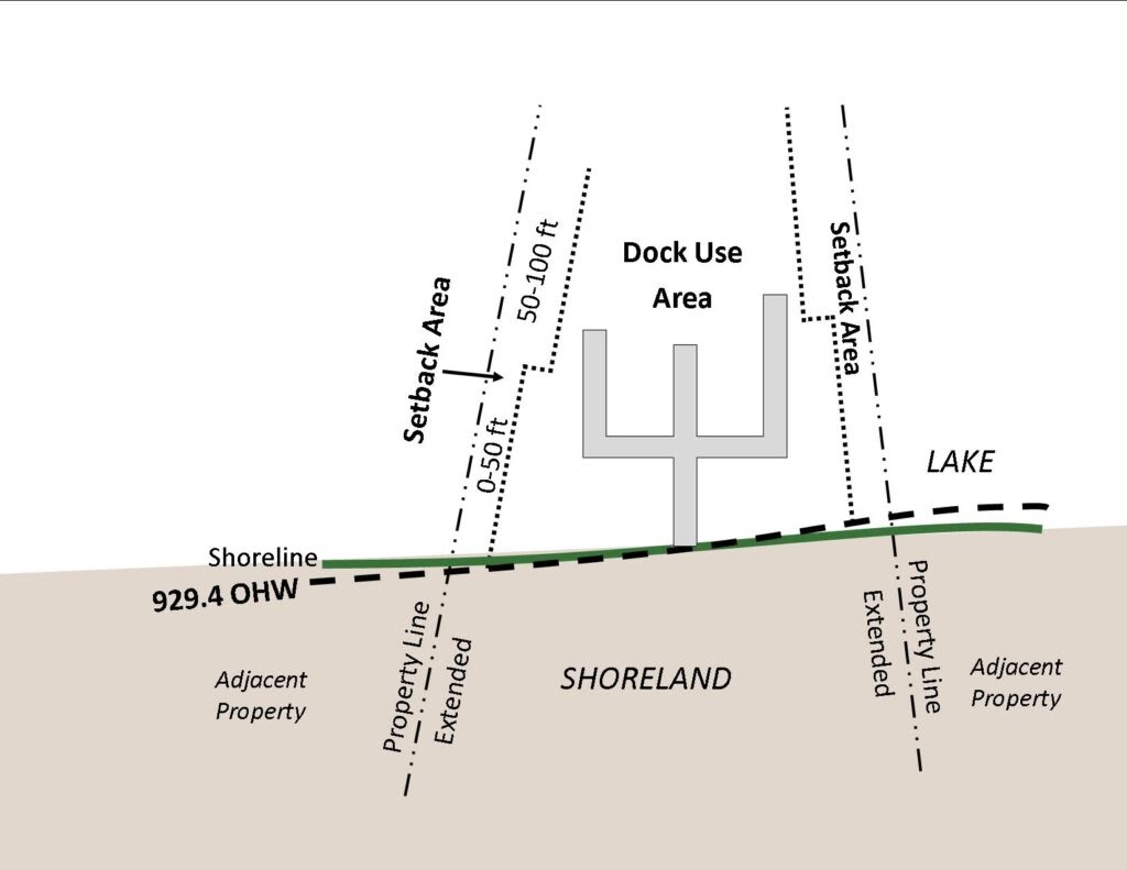
Setbacks
- Dock length of 0-50 feet- 10 feet setback
- Dock length 50-100 feet- 15 feet setback
- Shoreline 50 feet or less; if in existence on 02/02/1970- 5 feet setback, if in no way impairs access to neighboring docks or public
- Slip opens into adjacent property (side opening)- Depth of slip with a minimum of 20 feet
- Canopy fabric exceeding 30 inches vertically- 20 feet setback
LMCD regulations regarding dock structures, setbacks, watercraft density, and more are summarized on the Residential Docks, Structures, and Watercraft handout. View the complete code of ordinances for details.